Water Eaton Walk
A nice flat walk from Oxford Parkway station to Cutteslowe Park with its little railway and gardens and the historic Water Eaton Manor.
Walk Facts:
Distance: 9.43 km / 5.86 miles
Total Climb: just gentle climbs, the route is almost flat.
Walked: September 2021.
The route:
Getting there:
Parking costs around £2 (at time of walking) and you can use the Ringo App to pay, or head in to the station building.
There is a cafe and toilets at the station, and at the Bus terminal.
Regular busses go in to Oxford and Kidlington, trains run to Oxford, Bicester and London Marylebone.
The details:
Start at water Eaton Park and ride or Oxford Parkway car park.
From the front of the railway station take the pathway that climbs up to the main road and a bus stop, then head south (towards Oxford) crossing over the traffic lights for the entrance to the park-and-ride and then continuing until you get to the entrance to Water Eaton Farm. Turn left (east) and take the the bridleway, which is a nice concrete farm road.
After around a kilometre, when the concrete road turns to the left you’ll find a signpost marking out a footpath to the right to Cutteslowe Park follow it heading south.
The path does a dog-leg south east and then turns back south-ish.
After a short while the track turns to the east again together with the hedge, but you want to stay with the footpath which continues straight on across the field from that bend.
Through the gap in the hedge and straight across the next long field.
Through another hedgerow and a little bridge and cross a corner of a field to another hedgerow and another bridge which takes you into Cutteslowe Park.
The park has many paths and things to see, it’s worth spending a little time and wandering around. You will arrive at the sports fields but further south there is a walk through some woods that takes you clockwise around the a large pond, a nursery and cafe, some gardens and even a little train ride. When you have had your fill, head back to the sports fields and where you came in.
More information on Cutteslowe Park here.
Our return journey covers some of the ground we’ve already walked, so out of Cutteslowe Park the same way you came in and then head back across the field passing through a hedgerow.
About halfway across the next much larger field you’re going to turn right following a footpath which is barely visible. When I walked this there was a ghost of a tractor trail just before you get to a Telegraph poll (not the big power cable though) it takes you east towards a little cut through the hedge, which should help you find the way.
Once through I followed the left hand edge of the field to pick up a track again.
Follow the track through another hedge, across another short field again and through another hedge all continuing to follow the track.
At the end of the next field the trackway turns to the left and you’ll see a footpath continue straight on with a little bridge over the stream, cross it (you should see Water Eaton Manor in the distance).
Once again it’s hard to find the path, the OS says it goes straight across the field, but it looks like that hasn’t been walked in a while. If you keep to the left hand hedge you will eventually pick up the new path. Look out for a lone tree as a nice way marker.
Once you’ve crossed that field you pick up a pathway beside the hedge so turn to the right (east) and head towards the river.
The map says you should go as far as the bridge before turning almost back on yourself to cross following the Oxfordshire greenbelt way into the grounds of the old manner. But now that pathway actually picks up on your left hand side as you get to the end of the hedge row. So maybe go and have a quick look at the river take some nice pictures and then come back to the hedgerow and cross the field heading north you’ll see a nice white marker and a style in the hedge ahead.
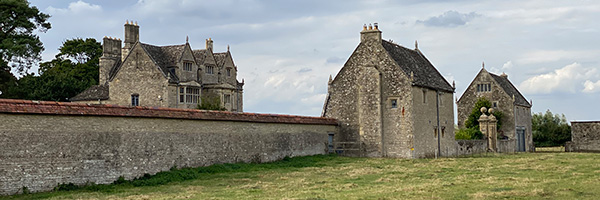
Over the style and into the grounds of water Eaton Manor. Watch out for the cattle!
Water Eaton manor house was built for Sir Edward Frere in 1586 but reduced in size at a later date. The Gothic Revival architect GF Bodley restored the house in 1890 and made it his home. It is now a Grade II listed building. You can read more about it on Wikipedia. Click here.
After you have passed the lovely house and buildings the pathway cuts between the wall and some buildings (one with a garage door!) to pass the chapel and then head north across the field following a very clear path.
Once you reach the fence with the signpost on the gate go through the gate going left and then back onto the track following that South again.
Pass the front drive to Water Eaton Manor and then continue along the concrete road back to the main road retracing your steps back to Oxford Parkway Station.
PMK